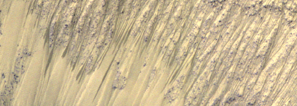
 Alfred S. McEwen, Colin M. Dundas, Sarah S. Mattson, Anthony D. Toigo, Lujendra Ojha, James J. Wray, Matthew Chojnacki, Shane Byrne, Scott L. Murchie and Nicolas Thomas ABSTRACT The presence of liquid water is a requirement of habitability on a planet. Possible indicators of liquid surface water on Mars include intermittent flow-like features observed on sloping terrains. These recurring slope lineae are narrow, dark markings on steep slopes that appear and incrementally lengthen during warm seasons on low-albedo surfaces. The lineae fade in cooler seasons and recur over multiple Mars years. Recurring slope lineae were initially reported to appear and lengthen at mid-latitudes in the late southern spring and summer and are more common on equator-facing slopes where and when the peak surface temperatures are higher. Here we report extensive recurring slope linea activity in equatorial regions of Mars, particularly in the deep canyons of Valles Marineris, from analysis of data acquired by the Mars Reconnaissance Orbiter. We observe the lineae to be most active in seasons when the slopes often face the sun. Expected peak temperatures suggest that activity may not depend solely on temperature. Although the origin of the recurring slope lineae remains an open question, our observations are consistent with intermittent flow of briny water. Such an origin suggests surprisingly abundant liquid water in some near-surface equatorial regions of Mars. Nature Geoscience Download the AGU presentation slide Download the presentation video clip (720p, MP4) Read the JPL press release ANIMATED GIFS OF RSLs (Please note the animations may take a moment to load fully) Heavily dissected hill in Juventae Chasm 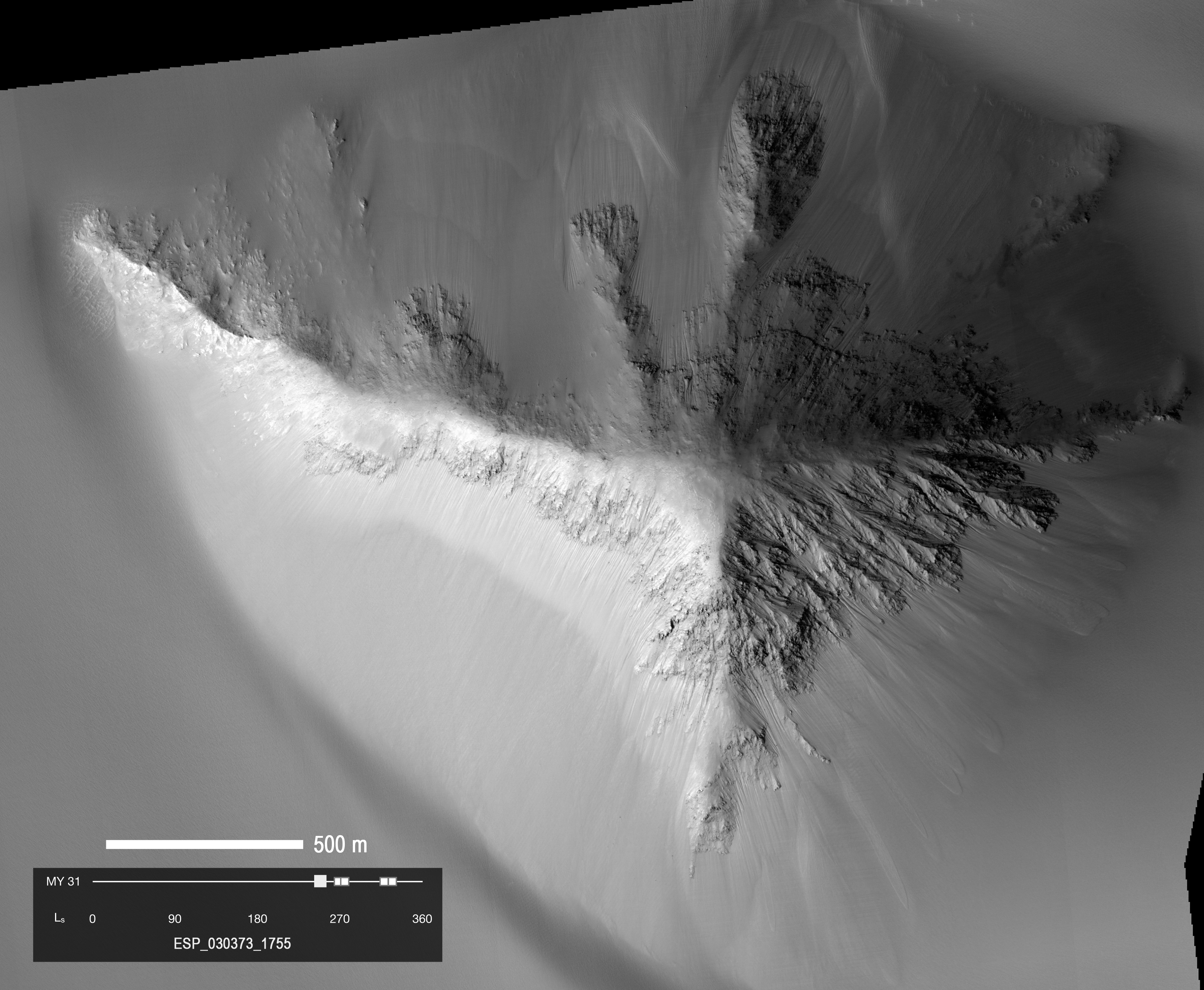 Sequence of 5 HiRISE images of a heavily-dissected (eroded) hill in southern Juventae Chasm, Mars (latitude 4.7 degrees S, longitude 298.6 degrees E).
This sequence is from the recently completed Mars Year (31), and RSL were also seen here in Mars Year 28, so they have recurred. The season of these
images is late spring to early summer in the southern hemisphere, and include perihelion (Mars closest to the sun in its orbit). Activity is strongly
concentrated on the south-facing slopes, which are the warmest slopes this time of year. The RSL are closely associated with “small” (for Mars) gullies.
Images reduced to 1 m/pixel scale. (31MB)
Sequence of 5 HiRISE images of a heavily-dissected (eroded) hill in southern Juventae Chasm, Mars (latitude 4.7 degrees S, longitude 298.6 degrees E).
This sequence is from the recently completed Mars Year (31), and RSL were also seen here in Mars Year 28, so they have recurred. The season of these
images is late spring to early summer in the southern hemisphere, and include perihelion (Mars closest to the sun in its orbit). Activity is strongly
concentrated on the south-facing slopes, which are the warmest slopes this time of year. The RSL are closely associated with “small” (for Mars) gullies.
Images reduced to 1 m/pixel scale. (31MB)
RSL and darkening fans in East Coprates Chasm 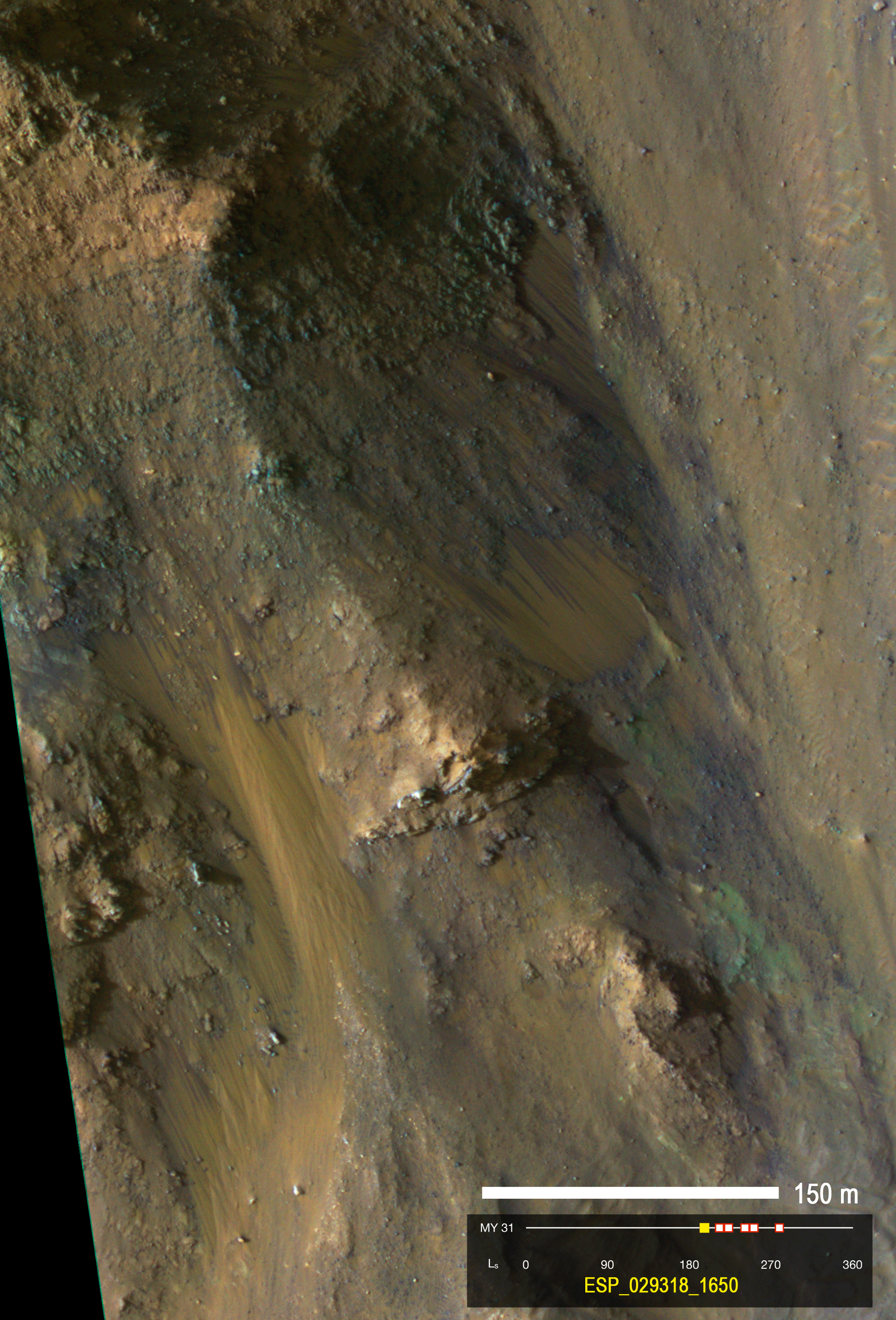 Sequence of 6 images showing a small area of steep slopes with RSL activity (latitude 14.7 degrees S, longitude 304.6 degrees E). The sequence is in Mars Year 31,
southern spring. Note that some of the fans that RSL flow over became darker and brighter over time
(see also figure S2 of the supplementary material of the Nature Geoscience paper).
There are many other such fans in this region that darkened and brightened at the same times. Image 0.25 m/pixel scale; scene 480 meters wide. (18MB)
Sequence of 6 images showing a small area of steep slopes with RSL activity (latitude 14.7 degrees S, longitude 304.6 degrees E). The sequence is in Mars Year 31,
southern spring. Note that some of the fans that RSL flow over became darker and brighter over time
(see also figure S2 of the supplementary material of the Nature Geoscience paper).
There are many other such fans in this region that darkened and brightened at the same times. Image 0.25 m/pixel scale; scene 480 meters wide. (18MB)
RSL follow the sun in crater on Melas Chasm floor 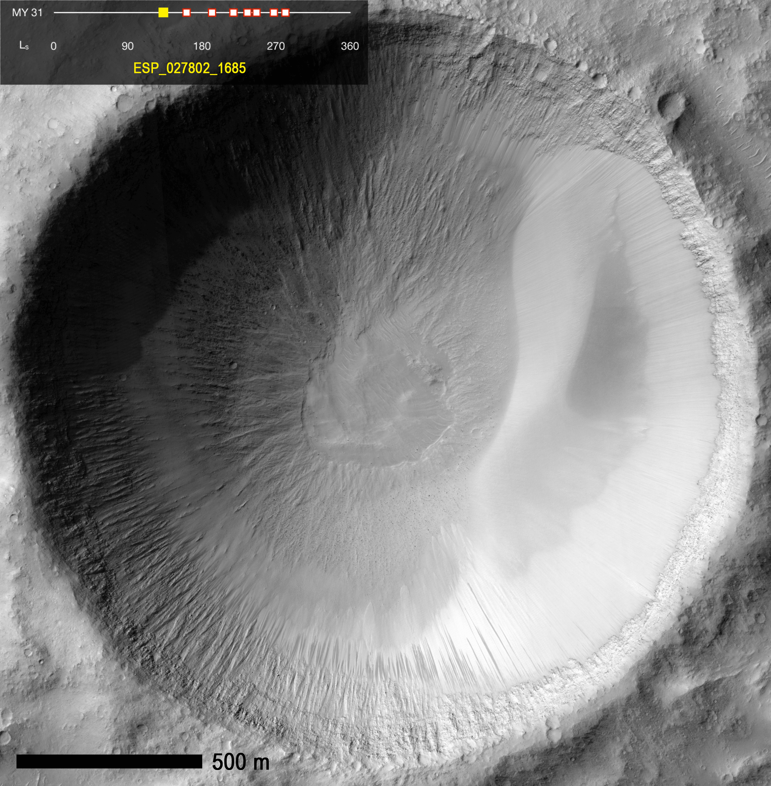 Sequence of 8 images showing RSL forming first on the north-facing slope (bottom), then switching to the south-facing slope (top). This change occurred close
to when the subsolar latitude moved from the north to the south of the latitude of this crater. In other words, RSL are most active on the slopes that receive more
direct sunlight. There was also an episode of inactivity and fading of RSL on the south-facing slope, when the air over this region was especially dusty
(Ls 235-246). Dusty air makes the daytime temperatures cooler, which may have temporarily stopped the RSL activity. (42MB)
Sequence of 8 images showing RSL forming first on the north-facing slope (bottom), then switching to the south-facing slope (top). This change occurred close
to when the subsolar latitude moved from the north to the south of the latitude of this crater. In other words, RSL are most active on the slopes that receive more
direct sunlight. There was also an episode of inactivity and fading of RSL on the south-facing slope, when the air over this region was especially dusty
(Ls 235-246). Dusty air makes the daytime temperatures cooler, which may have temporarily stopped the RSL activity. (42MB)
RSL activity on complex topography in East Coprates Chasm 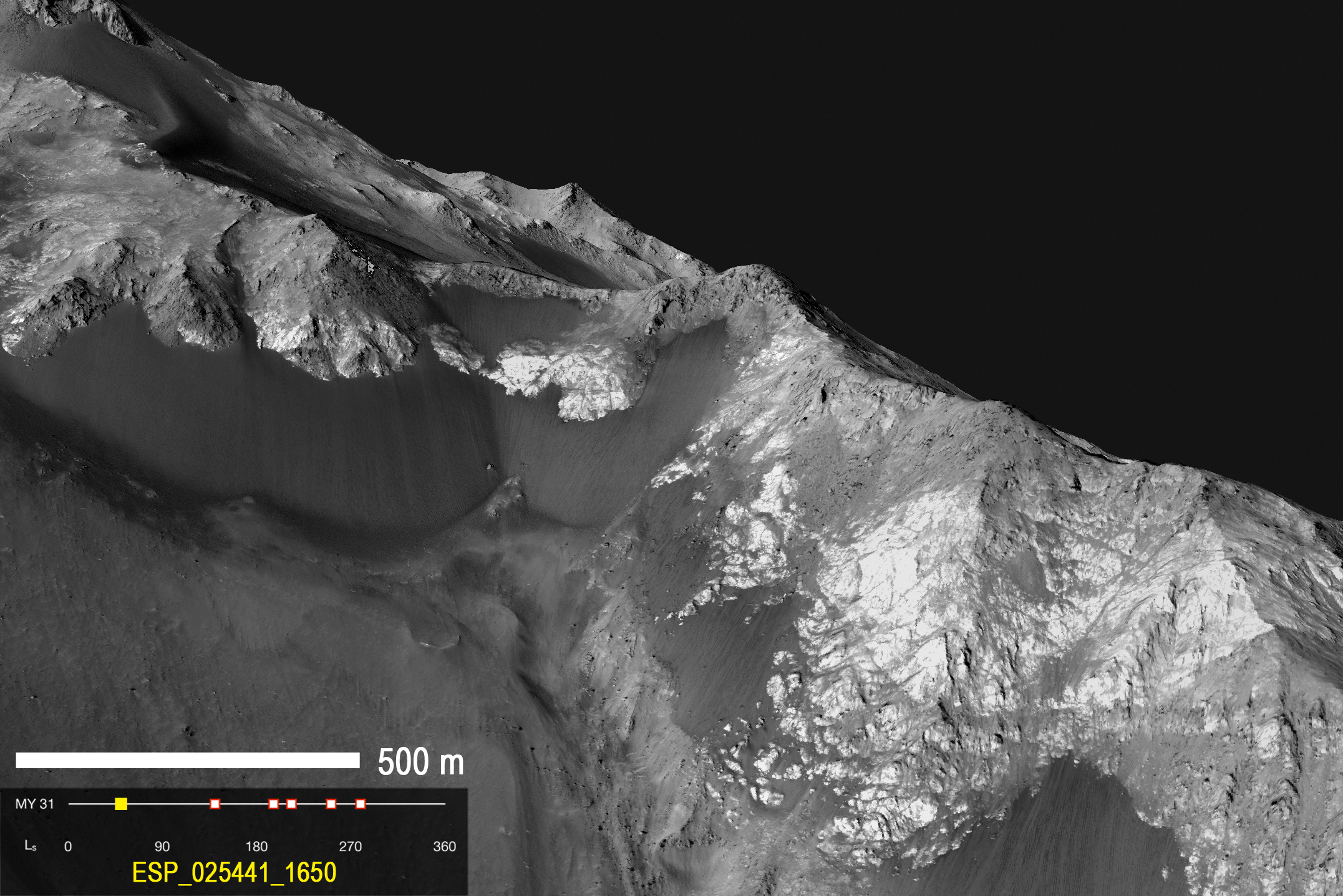 The use of digital terrain maps (DTMs), constructed from HiRISE stereo images, helps characterize the RSL phenomena. The images in other sequences have been DTM-projected
to looking straight down on the surface, but here that have been projected to a view a person or rover on the surface could observe. This sequence of 6 DTM-projected
images shows RSL forming and fading on west-facing slopes in east Coprates Chasma (latitude 14.7 degrees S, longitude 304.6 degrees E).
North is to the left, and most slopes face south. Flows appear to form from the upper-most 100 meters along this ridge, suggesting very concentrated sources,
possibly from the light- and mid-toned bedrock. Activity here is observed on all slope aspects and for the majority of the year, but RSL generally favor Sun-facing slopes. (13MB)
The use of digital terrain maps (DTMs), constructed from HiRISE stereo images, helps characterize the RSL phenomena. The images in other sequences have been DTM-projected
to looking straight down on the surface, but here that have been projected to a view a person or rover on the surface could observe. This sequence of 6 DTM-projected
images shows RSL forming and fading on west-facing slopes in east Coprates Chasma (latitude 14.7 degrees S, longitude 304.6 degrees E).
North is to the left, and most slopes face south. Flows appear to form from the upper-most 100 meters along this ridge, suggesting very concentrated sources,
possibly from the light- and mid-toned bedrock. Activity here is observed on all slope aspects and for the majority of the year, but RSL generally favor Sun-facing slopes. (13MB)
RSL and colorful fans along Coprates ridge 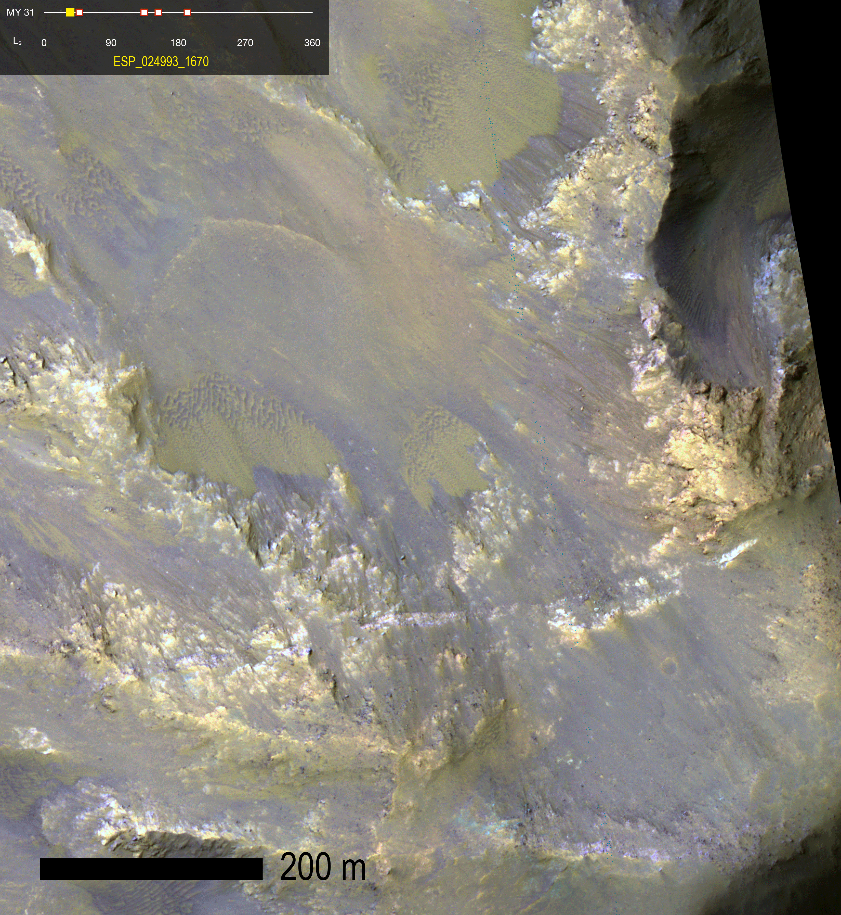 This site along Coprates ridge shows RSL on generally north-facing slopes in northern summer/southern winter (latitude 12.9 degrees S, longitude 295.5 degrees E).
South is down, and most slopes face northwest. IRB color (near-infrared, red, and blue-green bandpasses displayed as red, green, and blue, respectively) with
a min-max stretch illustrates the “greenish” fans and deposits associated with RSL. Two of these fans transition downslope into ripples
(see also figure 2 of the Nature Geoscience paper). All of the
lineae here and in the larger scene appear to originate from relatively bright bedrock outcrops. Note that some of the fans that RSL flow over became
darker and brighter over time. Image is approximately 950 meters wide. (33MB)
This site along Coprates ridge shows RSL on generally north-facing slopes in northern summer/southern winter (latitude 12.9 degrees S, longitude 295.5 degrees E).
South is down, and most slopes face northwest. IRB color (near-infrared, red, and blue-green bandpasses displayed as red, green, and blue, respectively) with
a min-max stretch illustrates the “greenish” fans and deposits associated with RSL. Two of these fans transition downslope into ripples
(see also figure 2 of the Nature Geoscience paper). All of the
lineae here and in the larger scene appear to originate from relatively bright bedrock outcrops. Note that some of the fans that RSL flow over became
darker and brighter over time. Image is approximately 950 meters wide. (33MB)
Animated GIF captions by: Matt Chojnacki and Alfred McEwen Image credit: NASA/JPL/University of Arizona |
|
Home Updates Catalog Captions Anaglyphs Stereo Pairs DTM Science in Motion HiWish HiView Search Special Releases HiFlyers HiClips Science Themes Software Camera Specs FAQ Image Usage Policy Contact Us The BEAUTIFUL MARS Project French German Spanish Portuguese Italian Dutch Icelandic Russian Greek Arabic Turkish Polish Ukrainian Latin Hebrew Chinese Esperanto MRO PIRL Lunar & Planetary Laboratory University of Arizona |


HiRISE Operations Center 1541 E. University Blvd Tucson, Arizona 85721 © 2014 Arizona Board of Regents |