
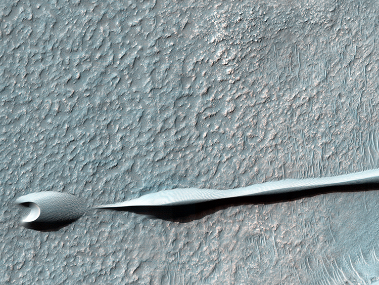
 Over the course of its mission, the science instruments on board the Mars Reconnaissance Orbiter (MRO) have returned over 200 terabits of data back to Earth. This image was taken on 4 November 2013, the same day that MRO’s 200-terabit mark was surpassed. (This equals 25 Terabytes of data, or well over 5,400 DVDs.) Sand dunes such as those seen in this image have been observed to creep slowly across the surface of Mars through the action of the wind. These are a particular type of dune called a “barchan”, which forms when the wind blows in one direction (here, east to west) for long periods of time. Barchan dunes are common on Mars and in the desert regions of the Earth. These barchan dunes are located on the western rim of the Hellas impact basin, in the Southern hemisphere of Mars. This area is covered by extensive deposits of layered rocks that were initially deposited as loose sediments and over time formed these rock layers. Portions of these layered rocks were subsequently eroded away and the remaining layers now form numerous flat-topped hills called mesas. The barchan dunes are forming in the lee (downwind) of the mesas. This area was previously image by HiRISE in 2008 and was retargeted here through a public request via HiWish. Careful comparison of repeat images such as these can reveal the speed and manner by which dunes move across the martian surface. This information can be used to study the current atmosphere of Mars, the age and mobility of sand deposits on the planet’s surface, and the hazards that sand dunes may pose to landed vehicles such as rovers. Written by: Chris Okubo Image credit: NASA/JPL/University of Arizona |
|
Home Updates Catalog Captions Anaglyphs Stereo Pairs DTM Science in Motion HiWish HiView Search Special Releases HiFlyers HiClips Science Themes Software Camera Specs FAQ Image Usage Policy Contact Us The BEAUTIFUL MARS Project French German Spanish Portuguese Italian Dutch Icelandic Russian Greek Arabic Turkish Polish Ukrainian Latin Hebrew Chinese Esperanto MRO PIRL Lunar & Planetary Laboratory University of Arizona |


HiRISE Operations Center 1541 E. University Blvd Tucson, Arizona 85721 © 2014 Arizona Board of Regents |